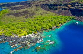
Kealakekua Bay
A place of both historic and natural importance, Kealakekua Bay along the Big Island’s western coast is a remarkable spot to hike, snorkel and see the sights.

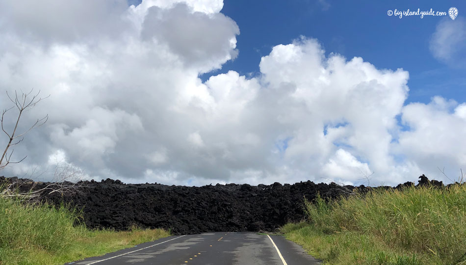
The Kapoho Tide Pools were destroyed by the 2018 Volcanic Eruption of Kilauea. Sadly this area was covered by the active lava flow originating from Fissure 8 and is now closed to the public. The coral and the sea life in this small ecosystem has been destroyed by an active ocean entry of lava that changed the face of this 2 mile area of the Big Island. Black sand beaches, small off shore islands, and an ever evolving coastline was formed by the Kilauea Eruption and only time will tell what this area will become.
I’m leaving a lot of information in this article about what it was like before the eruption, just to explain how special this area was. Snorkeling at the Kapoho Tide Pools was a highlight of a visit to the eastern Hilo side of the Big Island. Located in the Waiopae Marine Life Conservation District, we often heard from visitors that this was one of their best snorkeling experiences on the island, and it was certainly one of our favorites.

The name Kapoho means “the depression” in the Hawaiian language, a reference to the shape of the tide pools. The physical characteristics of the Kapoho Tide Pools were similar to a barrier reef where a shallow basalt ridge on the ocean side of the tide pools causes shore break, protecting the pools from the stronger currents.
The pools got excellent water circulation by northeast trade wind-generated surges that nourished the abundant coral and marine life. There was diverse coral growth in the tide pools supporting a bountiful array of marine life. This made the environment a nursery for fishes, and consequently, the area was a protected marine conservation area.

Snorkeling at the Kapoho Tide Pools
An expansive labyrinth of protected tide pools and lava rock causeways set the stage for snorkeling at Kapoho. There were abundant interconnecting tide pools that extended up to 200 yards offshore. Many of the pools were large and deep enough to provide room for swimmers and snorkelers. A unique feature was that some of the pools contained warm geothermal brackish water, some estimated to reach up to 90 degrees F. Several beach homes along the shore actually contained some of these tide pools within the boundaries of their property line as dipping pools or hot tubs.
The tide pools were made up of pahoehoe lava (referring to the smoother surface of the flows). The pools’ underwater surfaces were full of colorful marine life and coral growth. Snorkelers enjoyed the interior tide pools, especially on a clear day when the sun’s rays illuminated the shallows. Visibility was murkier towards the ocean. The maximum depth was about 4 meters and was not recommended for scuba diving.
Previous 1960 Volcanic History of Kapoho and the Power of Kilauea
Kapoho, Hawaii, near the Kapoho Tide Pools, was an independent community in the Puna district on the Big Island, located near the easternmost end of Kilauea’s east rift zone. In 1960 Kīlauea Volcano erupted destroying nearly 100 homes and businesses as well as, a hot spring resort. The Cape Kumukahi Lighthouse east of the town was spared and continues in operation.

On January 12, 1960, residents of Kapoho experienced over 1,000 small earthquakes shaking the area. HVO seismologists used a portable seismograph to pinpoint the source of the swarm as an area just north of Kapoho village, 25 miles down the east rift zone from Kilauea’s summit. The size and frequency of the earthquakes increased sharply after midnight on January 13. By daybreak, the ground was severely fissured through town, and the roughly 300 residents evacuated.
The eruption started in the evening above Kapoho. Although the main drift of lava flowed into the ocean, a slow-moving subsidiary inched towards the town of Kapoho. Deterring the lava flow with rock barricades and attempting to harden the lava by cooling it with water, proved futile and on January 28 it entered Kapoho and buried the town. The flows from this eruption entered the ocean just north of the tide pools and the Kapoho area has since been rebuilt as a community of private homes and vacation rentals.
Kapoho Tidepools Location
The Kapoho area is currently inaccessible due to the 2018 lava flow, please do not attempt to reach this area.
14-4984 Waiopae Rd
Pāhoa, HI 96778

A place of both historic and natural importance, Kealakekua Bay along the Big Island’s western coast is a remarkable spot to hike, snorkel and see the sights.

Located in the heart of Kailua-Kona, Kamakahonu Beach is the perfect spot for a quick beach trip between other activities during your Hawaiian vacation.

With its picturesque bay and classic palm tree dotted shoreline, beautiful A-Bay is one of the Big Island’s most stunning beaches to take sunset photos.
