A Visit to Hilo May be the Best Bang for Your Buck
Big Island Guide
Travel Guide

Positioned on the tropical eastern side of the Big Island, Hilo is home to stunning waterfalls, beautiful gardens and lush rainforests. A visit to this city is the perfect opportunity to travel back in time and witness a laid-back, serene version of Hawaii that isn’t often replicated today. The city is the largest on the Big Island, but remains a true Hawaiian community with a friendly community, gorgeous city parks, and local events.
While the natural attractions surrounding Hilo rival many others on the Big Island, visitors seeking a more urban experience in their travels should consider Hilo a must-visit destination. Home to the University of Hawaii-Hilo, the city has a more college town vibe than anywhere else on the Big Island.
Live music, festivals, art galleries, and restaurants populate this eastern Hawaiian town, but there’s plenty to learn, too. The Imiloa Astronomy Center, the Lyman Museum, Pacific Tsunami Museum, and plenty of talks and lectures at UH-H provide stimulation for guests and residents alike. Hilo is home to the only rainforest zoo in the United States, the Panaewa Rainforest Zoo, which hosts exotic plants, animals, and exhibits.
While it’s more than 2 hours away from Kailua-Kona, Hilo is a convenient home base for guests seeking out scenic highways, waterfall tours, and Hawaii Volcanoes National Park. Lodging ranges from vacation rentals, hostels, and a few major hotels.
Partly due to the university presence in Hilo, the city is livelier and yet more modest than Kailua-Kona. Many of the buildings here are of the original constructions, with the downtown corridor made up of historic storefronts, theaters, and office buildings. Small shops, galleries, cafes, and restaurants populate the streets, but major shopping areas aren’t as prominent here as on the opposite side of the Big Island, prompting weekend road trips for residents seeking affordable groceries and goods.
The city is somewhat more affordable than its western cousin and the local population in Hilo is larger than in Kailua-Kona. More than a third of the city is of Asian descent and 15% identify as Native Hawaiian or Pacific Islander.
While served by an international airport to the east, Hilo doesn’t receive the same level of tourist activity as the western side, which is more associated with sandy beaches and sun-soaked resorts. In 2015, only 46,000 tourists arrived to Hilo by air compared to nearly 700,000 to Kona. Visitors looking for an atypical look at Hawaii with a local flair should seek out the eastern side of the island as an alternative to the Kohala Resort area.
Receiving more than 126 inches of rain each year, Hilo is particularly susceptible to tropical storms and tsunamis. Two devastating tsunamis occurred in 1946 and 1960, prompting the creation of the Pacific Tsunami Museum in 1994, but no major tsunami has occurred since 1975. Nevertheless, tsunami warning systems and evacuation routes have been established in the area in the years since the destruction of several coastal towns in 1946.
Nestled between the coast and the bases of both Mauna Kea and Mauna Loa, the city of Hilo is the county seat of Hawaii County, which encompasses all of the Big Island. It’s the fourth wettest city in the United States behind Alaskan communities of Whittier, Ketchikan, and Yakutat, making it among the wettest in the world. Varying by altitude, some areas of Hilo receive more than 200 inches of rain per year and citizens experiencing more than 270 days of rainfall on an annual basis.
Due to the funnel shape of Hilo Bay, the city and surrounding area are particularly vulnerable to tsunamis and tropical storms.
Somewhere around 1100 A.D., Hilo’s first permanent residents arrived and brought with them Polynesian traditions. Archaeological proof is scant, but oral histories refer to the first inhabitants settling around the Wailuku and Wailoa Rivers.
The name “Hilo” first referred to the entire stretch of the eastern side of the Big Island, but, is now divided into two districts: North and South. The first European visitors to the region found the primary settlement to be along the south shore of Hilo Bay, but missionaries in the 19th century established the Haili Church in the area of present-day Hilo. In the years that followed, this area became the economic powerhouse on the island, with booming sugar plantations prompting the construction of a railroad in the early 1900s.
A major tsunami struck Hilo on the morning of April 1, 1946, taking 122 lives and destroying much of the downtown storefronts and railroad tracks critical to the transportation of sugar from inland. While the damage was substantial and remains the worst tsunami in the history of the Big Island, the resulting destruction and loss of life prompted an area-wide tsunami warning system that successfully alerted residents to subsequent tsunamis in 1952 and 1957.
As with much of the Big Island, the downturn in the sugar trade impacted this area greatly. Sales and consolidation, coupled with modernization of equipment, reduced employment opportunities around Hilo. Recently, commercial developments and artisanal farming have restored some of the economic viability of the city, though the tourism money found elsewhere on the Big Island isn’t present on the same levels in and around Hilo.
Despite the near-constant rainfall, life here moves a bit slower – even compared to other areas in Hawaii. The hustle-bustle of tourism just doesn’t exist to the same degree here and local events, activities, and the presence of the University of Hawaii-Hilo keeps the city humble. Live music, art galleries, the historic Palace Theatre, near-constant street festivals, farmer’s markets, and other community activities make the city feel like home rather than another vacation spot.
keep exploring


Visiting Hilo during the annual Merrie Monarch Festival is a wonderful opportunity to explore and enjoy traditional Hawaiian hula, arts and crafts, music, and fun local events.

Some of the finest chefs in Hawaii call Hilo home and the number of delicious eating establishments are many.

Visitors can explore the heavens and learn about ancient Hawaiian navigation techniques, combining history and science in a way unlike any other place.

A long-time favorite for Big Island aerial tours, Safari Helicopters Hawaii offers an incredible perspective on some of the island’s greatest natural features.
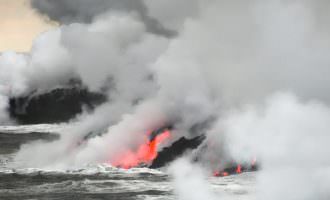
From the red glow of molten lava, to ocean entry plumes and exciting crater activity, watch the Big Island’s lava flow and volcanic activity of Kilauea.
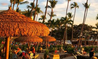
Enjoy one of the best sunset dinner shows on the Big Island, presenting the legends and lore of Polynesia, with oceanfront dining and dancing.
Fly high on a parasail and enjoy an awe inspiring bird’s eye view hundreds of feet above the Big Island’s Kona Coast.

Explore the underwater world of the dolphin in this exciting dolphin video from Kona Hawaii.

in historic downtown Hilo you will find the beautiful Lili’uokalani Gardens, the largest, authentic Edo-style ornamental garden outside of Japan.

With intense volcanic activity over millions of years, there are hundreds of lava tubes, caves, and volcanic formations to explore on the Big Island.

There’s no shortage of unique restaurants and dishes to try during a stay in Hilo, but these are some sure-fire favorites.

Offering a well-rounded tour experience that takes you to the top of the Big Island’s greatest geologic feature, Mauna Kea Summit Adventures makes reaching the summit easy.

One of the most sophisticated and informational interpretative centers in Hawaii, Mokupapapa Discovery Center provides unique insight into the protected marine waters and history of the Big Island.

A unique gathering of local artists on the Big Island, the East Hawaii Cultural Center provides incredible insight and access to Big Island works of art, performances, and exhibitions.

When the lava reaches the ocean, Hawaii lava boat tours are an unforgettable experience that brings you to the incredible ocean entry of the lava flows for an impressive view.

The Mauna Loa Macadamia Nut Corporation offers a fun and tasty visitor center experience for guests to the Big Island.

Spanning throughout the Big Island’s most notable natural attractions, Paradise Helicopters offers luxury aerial tour experiences the whole family can enjoy.

A long-time favorite for Big Island aerial tours, Safari Helicopters Hawaii offers an incredible perspective on some of the island’s greatest natural features.

Helping to maintain the history and culture of the Big Island’s past residents, the Lyman Museum and Mission House holds an important role in preserving their contributions.

A specialized tour company with an emphasis on customer service, a tour with Keikana Tours promises an action-packed adventure.

A living memorial to the victims of tsunamis in Hawaii over the years, the Pacific Tsunami Museum shares their lives and stories.

This 12 acre zoo and garden offers a fun and free family activity in Hilo, Hawaii and is celebrated as the only naturally, occurring tropical rainforest zoo in the United States.

An incredible opportunity to experience the lava flows in Hawaii Volcanoes National Park up close and personal, Volcano Bike Tours offers affordability and reliability throughout your tour.

The Naniloa Golf Course is a gorgeous 9-hole course with incredible views and exciting golf along the Big Island’s eastern side.

Nani Mau, meaning Forever Beautiful, is a gorgeous botanical garden and event center with orchards and flower gardens.